New Analysis From Transportation Alternatives and MIT Details How Inequities in Public Space Contribute to Racial and Economic Disparities Across New York City Neighborhoods
Spatial Equity NYC, a New Online Data Tool Released by Transportation Alternatives and the Norman B. Leventhal Center for Advanced Urbanism at MIT Reveals the Impact of Car-Centric Planning and Policies on Public Health, the Environment and Mobility
Spatial Equity NYC 2022 Report Card delivers an in-depth analysis — with rankings across 51 Council Districts and 59 Community Boards — of how different communities benefit or suffer from the distribution of bus lanes, park access, car traffic, air pollution, and more.
Transportation Alternatives and partners call on New York City’s elected leaders to immediately correct the legacy of spatial inequity and disinvestment by implementing NYC 25x25 and converting space dedicated to cars into space that prioritizes people.

NEW YORK — There is an alarming inequity in how public space is used across New York City and how this results in vast disparities for the public health, environmental resilience, and mobility of different neighborhoods, according to Spatial Equity NYC, a groundbreaking new online tool and report card released today by Transportation Alternatives and the Norman B. Leventhal Center for Advanced Urbanism (LCAU) at the Massachusetts Institute of Technology.
As just one example from the new report card, compared to the 10 City Council districts with the largest white populations, in the 10 City Council districts with the largest populations of people of color:
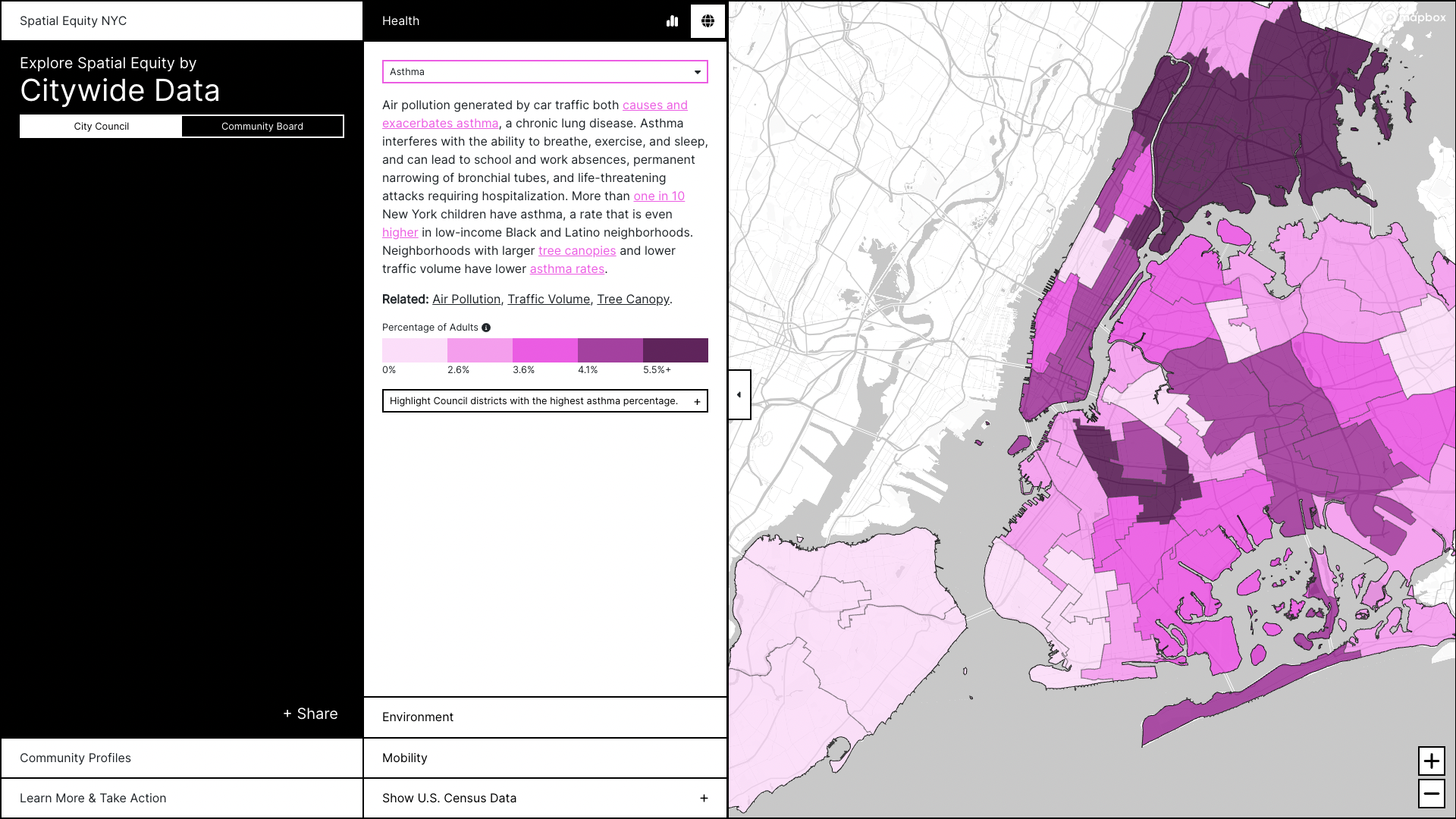
Asthma rates are 96 percent higher.
83 percent fewer streets with protected bike lanes.
64 percent fewer bike parking spaces.
57 percent fewer streets with bus lanes.
Traffic injury rates are 58 percent higher.
Spatial Equity NYC analyzes publicly-available data to measure, compare, and visualize how different uses of public space — from high-traffic volume streets to bus lanes to parks — impact residents across New York City neighborhoods. Through 15 initial data sets, with more to be released in coming months, Spatial Equity NYC makes clear the dramatic and deadly results of years of inequitable use of public space by the City of New York. Pulling in raw data provided by the US Census Bureau and the City of New York, Spatial Equity NYC is a one stop shop for policymakers and the public to get a clear look at disparities and provides concrete solutions to fix these inequities.
“Spatial inequity results in worse health outcomes, longer commutes, and higher rates of traffic violence — and the harm disproportionately impacts low-income communities and communities of color,” said Danny Harris, Executive Director of Transportation Alternatives. “With streets being New York City’s largest public space, our leaders must enact NYC 25x25, a plan to reclaim 25 percent of street space for better use by 2025. Transforming car space into space that prioritizes people would improve public health, mobility, and the environment across the five boroughs. Our public spaces should improve our lives, not harm them, and this new tool equips our elected leaders to finally do something about it.”
“The City of New York produces an almost limitless supply of open data, but most of it is difficult for the average person to find and use. When building Spatial Equity NYC, we wanted everyday New Yorkers and policy-makers alike to have a tool that makes data more accessible, creating a pathway to make more informed decisions to improve our streets and neighborhoods. Spatial Equity NYC combines analysis with real-world solutions creating a guide for policymakers, advocates, and local residents to take action to achieve spatial equity in their communities,” said Professor Sarah E. Williams, Director of the Leventhal Center for Advanced Urbanism at MIT.
“Poll after poll makes clear that projects that put better space to better use — whether with protected bike lanes or dedicated busways — are supported by the large majority of New Yorkers,” said Philip Miatkowski, Director of Research at Transportation Alternatives. “Through Spatial Equity NYC, we make clear exactly where these popular investments are needed most, and how they can correct the destructive consequences of spatial inequity. Equity is a critical priority of the Adams administration and City Council, and through the solutions presented on our site and in NYC 25x25, policymakers have an actionable toolkit to make neighborhoods more equitable across the five boroughs. Spatial Equity NYC should be a clarion call to make these investments without delay.”
What is Spatial Equity?
In New York City, streets and sidewalks make up the majority of public spaces — and the overwhelming majority of this space (76 percent) is devoted to parking and moving cars. Devoting so much of New York City’s finite public space to car traffic has created widespread and deeply inequitable harms, especially to already vulnerable populations.
Spatial equity is a way to understand how public space — including streets, sidewalks, and green spaces — is distributed, restricted, used, and made unusable, and the different outcomes that result for different communities. Public space can be used positively — such as a bus lane that speeds up commutes — or negatively — such as impermeable asphalt that makes flooding worse.
Key Findings in Spatial Equity NYC 2022 Report Card:
The new online data tool allows analysis of spatial equity across fifteen categories, including: mobility (bike parking, bus speeds, bus lanes and busways, protected bike lanes, public seating, and traffic density), environment (including excess heat, park access, surface permeability, and tree canopy cover), and public health (including asthma rates, air pollution, noise pollution, traffic fatalities, and traffic injuries). It also includes demographic data from the US Census, allowing spatial analysis of these factors alongside race and ethnicity, poverty level, vehicle ownership, and commute mode.
Data for each of these categories is mapped and ranked across community boards and City Council districts. Each map can also be compared side-by-side with data pulled directly from the US Census.
Examples of analysis by demographic:
As just one example from the new report card, compared to the citywide average, in the top 10 City Council districts with the highest percent of households living below the poverty line:
There are 58 percent fewer streets with protected bike lanes
Asthma rates are 53 percent higher
Buses are 12 percent slower
Residents bike to work at roughly the same rate, are 22 percent more likely to ride transit, and are 30 percent less likely to drive to work.
Example of analysis by indicator:
In the 10 City Council districts with the highest daytime surface temperatures, 91 percent of residents are people of color, compared to 67 percent citywide.
In Council District 4 (population 155,199), the single City Council district which has the most streets with bus lanes, there are more miles of bus lanes than in the bottom 25 districts combined (combined population 3.98 million).
In Council District 3 (population 173,254), the single City Council district which has the most streets with protected bike lanes, there are more miles of protected bike lanes than in the bottom 23 districts combined (combined population 3.65 million).
Example of district-level analysis comparing two indicators:
Of the 10 districts with the highest levels of particulate matter 2.5 air pollution (PM 2.5):
Nine have less tree canopy cover than the citywide average
Nine have higher traffic volumes than the citywide average
Eight have slower bus speeds than the citywide average
Recommendations
To correct these inequities, TA recommends that New York City’s leaders convert car space into space that prioritizes people. This starts with enacting NYC 25x25, a vision endorsed by Mayor Adams in 2021. NYC 25x25 aims to convert 25 percent of car space into space for people by 2025, including new parkland, public plazas with seating, expansive tree canopy cover, car-free busways, and protected bike lanes — prioritized in communities that have born the brunt of historic disinvestment and racist planning.
By giving a meaningful percentage of the street back to people, the City of New York will save lives, improve air quality, build climate resilience into every roadbed, and set the tone for the future of New York as a vibrant and fair city with accessible, efficient transportation and robust, thriving street culture.
As part of the Spatial Equity NYC launch, Transportation Alternatives has launched a new petition, where New Yorkers can call on their City Council member to publicly commit to NYC 25x25 and combating spatial inequity by converting space for cars into space for people.
What Others Are Saying:
“Today, Transportation Alternatives and MIT unveiled a key new dataset for our city: Spatial Equity NYC. This new website offers a bird’s eye view into inequities in our city that cannot go ignored," said Public Advocate Jumaane D. Williams. "Every New Yorker deserves green space, clean air, fast buses, safe streets, and everything they need to thrive. With this new data, we have a guidebook on how to make every intersection, block, and neighborhood in our city a safer and better place to live. I look forward to working with my partners in government to turn this data into policy solutions.”
“Spatial inequity impacts the way we move, breathe, and survive in our city. This data shows how critical it is to expand our protected bike lanes, grow our tree canopies, and extend our dedicated bus ways to ensure our city’s built environment is more just and equitable. We cannot leave any neighborhood behind if we want to achieve climate and transportation justice across our whole city,” said Comptroller Brad Lander.
“Our city should be safe and healthy for the people who call it home, but right now we have primarily poor, Black and Brown communities where air pollution is soaring, asthma rates are high, and the streets are filled with fast-moving trucks and private vehicles that endanger our neighbors,” said Brooklyn Borough President Antonio Reynoso. “We must be willing to regulate and redesign how transportation intersects with our environment and public health. Spatial Equity NYC’s 2022 Report Card underscores the intense inequity and environmental racism facing communities of color while empowering our city to take immediate and long-term action. I’m grateful for Transportation Alternatives’ work and the efforts of so many advocates in this space who are building a movement to re-envision what a city of and for the people really looks like.”
"I commend Transportation Alternatives and MIT for creating this vital tool that will allow leaders and policy makers to not only understand the spatial inequity in our communities, but also address those inequities head-on," said Queens Borough President Donovan Richards Jr. "The Spatial Equity report shows that Queens has by far the most districts with the highest rated spatial inequity — and that is simply unacceptable. Our families deserve access to quality open space and our streets should belong to all our residents, regardless of their ZIP code or mode of transportation."
“As the author of New York City’s Open Data bill, I commend Transportation Alternatives for leveraging available information to identify patterns and trends regarding equity in public space. Inequities in the public realm contribute to adverse health and quality of life impacts, and most often harm historically marginalized communities. All New Yorkers deserve access to good public transit, clean air, and recreational space, and I will hold the Department of Transportation and others accountable to their promises and data,” said Council Member Gale A. Brewer.
“Spatial Equity NYC will provide my community with the tools to fight for more investment, better resources and ensure equity across New York City,” said NYC Council Majority Whip Selvena N. Brooks Powers. “This new online resource mapping tool provides local residents, community stakeholders, policymakers, and elected officials with a roadmap to advocate for better health, transportation, and environmental outcomes, in an accessible format to alleviate the disparities of the past. I applaud Transportation Alternatives and the Norman B. Leventhal Center for Advanced Urbanism for developing a centralized tool to create a more equitable future for all New Yorkers.”
"Spatial equity is one of our most vital objectives toward making this city as safe and healthy as it can be," said Council Member Tiffany Cabán. "We know that with streets that are safer for pedestrians and cyclists, more reliable and comprehensive mass transit coverage, and abundant clean air to breathe, we will achieve public safety and public health outcomes that are impossible under such dramatic spatial inequity. I'm proud to support this initiative, and want to extend my congratulations to Transportation Alternatives, Public Advocate Williams, the research team, and advocacy partners on releasing this critical data."
"The quality of our public spaces — their size and proximity to people, the amount of tree cover — have a direct effect on our health and wellbeing. Thanks to this new tool from Transportation Alternatives and MIT, we can now see clearly how rates of asthma, traffic deaths, and even heat deaths are the result of spatial inequity across our communities. The work of creating clean, green, open spaces for all is more urgent than ever,” said Council Member Shekar Krishnan.
“The Center for Independence of the Disabled, New York’s (CIDNY) goal is to ensure full integration, independence, and equal opportunity for all people with disabilities by removing barriers to the social, economic, cultural, and civic life of the community. “This means that all New Yorkers with disabilities have the right to safe, accessible, healthy, green space that promotes physical and mental wellbeing. We support initiatives that foster health inclusion to public space for people with disabilities. We advocate for accessible spaces and cleaner air which allows people with disabilities to live, work, play, and love while living in New York City,” said Sharon McLennon-Wier, PH.D., MSEd., CRC, LMHC, Executive Director of CIDNY.
“350Brooklyn was honored to review and participate in the launch of the Spatial Equity NYC. This tool fills a critical gap between data and actionable insights that will help us better ground our priorities in climate justice, focusing advocacy where it is needed most,” said Georgi Page, Sr. Organizer, 350Brooklyn, City Action Committee.
“Spatial Equity NYC is deeply a community service, putting actionable information into the hands of New Yorkers. It will be a powerful resource for community organizers and decision-makers who navigate critical questions of equity into the future. BetaNYC is honored to call TA an ally and we support this impressive effort to make public data accessible and actionable. If a picture is worth 1,000 words, these visualizations are a modern day encyclopedia, enabling anyone to navigate spatial equity in NYC,” said Jazzy Smith, Civic Innovation Fellowship Manager, BetaNYC.
"Community wellness depends on viable and accessible public space", said Matthew Clarke, Executive Director of the Design Trust for Public Space. “Given that a person's zip code is one of the best predictors of health, urban planners and city leaders must center health equity in the built environment. Transparency tools like Spatial Equity NYC are an important first step to disrupting the inequities driven by the relative quality of our neighborhoods’ spaces."
“To-date, crashes have killed more than 200 people on New York City streets in 2022. As Spatial Equity NYC makes clear, traffic violence doesn't impact every community equally. In City Council districts where the majority of residents are Black, there are 68 percent fewer streets with a protected bike lane, and a 39 percent higher rate of traffic injuries. This is unacceptable. Spatial inequity is deadly and we need our elected officials to take action now to save lives and make our streets more fair," said Fabiola Mendieta-Cuapio, member of Families for Safe Streets, whose 5-year-old son Bryan was killed in a car crash in October 2006.
“NYC-EJA congratulates Transportation Alternatives for this report, which echoes many of the same challenges, solutions, and themes NYC-EJA and our members have championed for years. This report supports our calls for targeted investments and interventions to mitigate air pollution, increase nature-based solutions, and electrify the transportation sector," said Eddie Bautista, Executive Director of the New York City Environmental Justice Alliance.
“Having access to Equity Data is essential to the work of organizing. Spatial Equity NYC allows you to compare communities throughout the city and can support communities' campaign for infrastructure projects, bicycle lanes, park and Greenway Development. The Harlem River Working Group will be glad to have access to these resources in our work to develop a Harlem River Greenway in the Bronx and to create publicly accessible on-water access,” said Chauncy Young, Coordinator for the Harlem River Working Group.
“Every so often a tool comes along that allows people to understand their surroundings and approach issues with fresh eyes, and that is exactly what Spatial Equity NYC does,” said Julie Tighe, President of the New York League of Conservation Voters. “From heat islands to asthma rates, from protected bike lanes to traffic fatalities, Spatial Equity NYC enables us to connect the dots from the inequitable conditions New Yorkers are forced to live with and the environment we, as a city, choose to create. We are grateful to Transportation Alternatives and MIT’s Leventhal Center for Advanced Urbanism for bringing this data to life.”
“Spatial Equity NYC is an important tool that will help New Yorkers visualize and reinforce the disparities that advocates on the ground are intimately aware of and present the policy and place-based solutions to eliminate them. When we seek to improve public spaces—their distribution, funding, prioritization, administration, management, design, and function—we also improve the livability of the city. Spatial Equity NYC reminds us of the urgency and opportunity to transform our public spaces to create a just, healthy, resilient, and equitable city,” said Spencer Williams, AICP, Assoc. AIA, Director of Advocacy, The Municipal Art Society of New York.
“The City collects enormous amounts of information about its streets and public spaces, including with respect to accessibility and environmental impacts. The NYC Spatial Equity Index marshals that data and unlocks its potential to benefit all New Yorkers, including people with disabilities and those belonging to environmental justice communities,” said Christopher Schuyler, Senior Staff Attorney with the Disability Justice Program at New York Lawyers for the Public Interest. “This tool will aid the work of NYLPI, and other advocacy groups, as we serve our client communities.”
"Public space is a public health issue, and Spatial Equity NYC makes that all too clear. Communities with less investment suffer the consequences — poorer physical and mental health outcomes, less livability, more dangerous streets.This tool should be an alarm bell and a blueprint; we urge our elected officials to immediately begin prioritizing investment in safe, joyful and well-managed public space for the most harmed communities," said Jackson Chabot, Director of Advocacy and Organizing at Open Plans.
"Providing clear, accessible, and actionable data to elected officials, stakeholders, and the general public is essential to creating a more open and equitable city," said Kate Slevin, Executive Vice President for Regional Plan Association. "RPA congratulates Transportation Alternatives and their partners for advancing the Spatial Equity NYC tool. We look forward to working with them to help drive public space investment in communities in order to improve access to open space and public health."
"Spatial Equity NYC is a powerful online tool that shows how open data can be leveraged to make the case for systemic change. We thank Transportation Alternatives and MIT for developing the platform and encourage government agencies, including the NYC Department of Transportation and others, to expand their open data offerings and ensure timely updates so that tools like Spatial Equity NYC can be as robust as possible," said Rachael Fauss, Senior Policy Advisor for Reinvent Albany. Reinvent Albany championed passage of NYC's landmark 2012 Open Data Law.
"Spatial Equity NYC is quickly becoming an essential tool in the fight for safe and equitable streets for all New Yorkers," said Riders Alliance Policy & Communications Director Danny Pearlstein. "With a couple of clicks, bus riders can find out how our communities stack up and hold officials accountable for change. Just one example: The Council District along Northern Boulevard whose member is opposing a new bus lane currently has no bus lanes anywhere in the district, tying for dead last among 51 districts in the City. This inequity alone should prompt Mayor Adams to immediately proceed with the project. Kudos to Transportation Alternatives for this important work."
“In a dense urban environment like NYC, nothing is more valuable than having safe and accessible public spaces. Spatial Equity NYC is a critical step to ensure equitable public spaces that prioritize New Yorkers, their families, and their communities,” said Scott Short, CEO of RiseBoro Community Partnership. “We commend Transportation Alternatives and MIT for creating a tool that can be utilized to invest in the future of our city and will allow New Yorkers to reclaim their communities.”
“Street Lab is very excited to use and share this important tool, which will help us all target our efforts and resources where they are needed most," said Leslie Davol, Co-Founder and Executive Director of Street Lab.
"Spatial Equity NYC, by taking difficult-to-parse city data and making it easy for anyone to analyze and compare, provides elected officials, planning entities, and all New Yorkers with an incredibly important and useful tool for visualizing and understanding –– and most importantly, beginning to rectify –– the stark inequity in our public spaces. We’re grateful to Transportation Alternatives and MIT for developing this invaluable resource,” said Eric McClure, Executive Director of StreetsPAC.
"As New York City and New York State prepare to apply for billions of dollars of federal transportation and infrastructure funds newly available through the Infrastructure Investment and Jobs Act (IIJA), the Spatial Equity NYC website shows us, using data not slogans, exactly where those investments are most needed," said Felicia Park-Rogers, Director of Regional Infrastructure Projects for Tri-State Transportation Campaign. "This website provides a critical tool for policy makers and planners to target where our investment dollars will have the most impact on improving health, equity, and project outcomes across our city."
“In Jackson Heights we have 7,000 kids who all attend title one-eligible schools in around 34 Avenue who now benefit from open space on our open streets. We have exchanged pollution, noise and injuries for fresh air, tranquility and safety. In one of NYC’s densest and most diverse neighborhoods we have harnessed the power of open space to build & strengthen our community,” said Jim Burke, Co-Founder of the 34th Avenue Open Street Coalition.
“Adam Clayton Powell Jr. Boulevard and Central Harlem has not been allowed to progress because elected and unelected government officials haven’t made the 80% of people who do not drive in Harlem a priority,” said TA Bronx/Uptown Committee Member Chris Sanders, campaign lead for the Central Harlem Bikeway Campaign. “The Spatial Equity Tool puts data and numbers behind what many people were already feeling in Central Harlem. It highlights the need for the Central Harlem Bikeway on Adam Clayton Powell Jr. Blvd.”
###
About Transportation Alternatives
For nearly 50 years, Transportation Alternatives has led the movement for safe, equitable streets in New York City because streets belong to the people of New York City. TA uses a combination of neighborhood-level grassroots organizing and citywide advocacy to push for changes in public policy, street design, enforcement, and resource allocation that transform our city’s streets for the better.
About MIT Norman B. Leventhal Center for Advanced Urbanism
Urbanism constitutes one of the most complex societal challenges of today’s world. MIT's Norman B. Leventhal Center for Advanced Urbanism (LCAU) is motivated by the radical changes in our urbanizing environment, and focuses on the design and planning of large-scale, complex, metropolitan environments. The LCAU’s mission is to establish a new theoretical and applied research platform to create knowledge that can be used to transform the quality of life throughout the urbanized world. LCAU is committed to achieving this goal through collaborative interdisciplinary research projects using design as a mode of inquiry, intellectual discourse, and dissemination through leadership forums, conferences, publications, and teaching.